Everything is somewhere
We'd like to provide easy, simple, quick access to the "where" information about people, places, events and things. We're especially interested in connecting people in communities with information about the things happening around them. And we prefer to do it using and building on the ubiquitous, free and open source spatial tools that other communities have already built.
OpenEarth are a small consultancy formed in 1998 in Sydney, Australia and now back in New Zealand, based in and working from Christchurch.
We have been involved with spatial information from its very start and can draw on our experience in the US, UK and Europe as well as extensively throughout Australia.
We are particularly enthusiastic and knowledgeable about Open Source Spatial Systems and Data as we think they greatly extend the possibilities for making effective use of the world's ever-increasing spatial information and genuinely improving our societies.
We can provide a range of services including
- How a spatial or mapping presence could be added to your existing information systems
- An evaluation of your existing spatial systems to see if they could benefit from newer technologies and data sources
- Determining how open source could be added to supplement or even replace existing proprietary solutions.
- Analysis of your existing or planned spatial processes and data management
- Development of specifications and architectures for new spatial systems
- Spatial database design and optimisation
- Spatial data sourcing, cleansing, structuring and presentation
- Spatial Software and Services development and implementation
- Hosting, Training, Documentation and on-going Support.
Much of our work can be and often is undertaken remotely but we can also travel in Australia / New Zealand to undertake agreed tasks and commissions.
PostGIS
PostGIS is a spatial extension to the popular Open Source relational database, PostgreSQL. It implements a powerful set of spatial abilities including 2D and 3D Vector, Raster and Linear Routing.
OpenEarth has many years of experience in both PostgreSQL and PostGIS and can develop spatial storage and analysis functions that help you visualise and gain insight into your data in new ways.
We can also provide tutorials and training in PostGIS and PostgreSQL to help staff get up to speed on the spatial aspects of Relational Databases. Because most Spatial commands are based on the SQL/MM standards, spatial queries are relatively portable between Spatial-supporting SQL databases.
GeoServer
GeoServer is an Open Source Java-based server for sharing and presenting geospatial data. It can access a wide range of data sources, analyse and manipulate the spatial data and present it as interactive maps that can be used to query the underlying information.
It can also supply raw image and vector based spatial information to a wide range of existing map clients (both Open Source and Proprietary) using the widely-adopted standards of the Open Geospatial Consortium (OGC)
Open Street Map
Open Street Map (OSM) is a community or crowd-sourced, Open Source map set of the entire world created by thousands of contributors throughout the world.
Spatial Odd Jobs

OpenEarth is a small, responsive consultancy that can quickly and easily provide solutions to problems which would be difficult or expensive to justify requesting from a larger organisation.
We have many years of experience in being a flexible, adaptable resource "on tap" for other organisations to quickly solve spatial and web problems of various sizes but especially those that are urgent or time-sensitive, and might require the application of a wide range of skills. We can also take on small jobs which might consist of as little as a few hours work. With our experience and skill set, we can accomplish, in hours, that which might take days internally.
OpenEarth runs its own servers and so can make results, as they are developed, easily available for viewing and discussion.
Typical requests might be to:
- Take the data from this spreadsheet and make a map with icons and colours reflecting particular attributes from the spreadsheet.
- Make the map interactive and access data from this other resource when a user clicks on an icon
- Tell me the number of 30-55 year old males living within 15km of all these addresses
- Create an API so my software can send an address and it responds with which of these sales areas that address is within
- Load all this data in Excel, CSV and PDF formats into a database, investigate potential ways to link the data, geocode the addresses and provide a web interface for creating customised PDF reports
- Create Microsoft Word docs that can automatically be populated with text and map images from a spatial database to create customised reports
Opening Closed Spatial Systems
It's noticable that even the predominant proprietary spatial systems are now taking Open Source Spatial tools and solutions seriously. Their newest offerings are often similar to, have learnt from or are even built on existing Open Source alternatives - javascript libraries such as JQuery, C3, D3, OpenLayers and Leaflet, extensive use of popular open browser technologies such as HTML5, CSS3, SVG and Web/GL, Open Source middleware such as GeoServer and Nodejs and open source spatial data stores such as PostGIS/PostgreSQL.
OpenEarth has quietly been ahead of the curve when it comes to Open Source Spatial Innovation. From a Google Maps-like web mapping solution, SPLASH, (Spatial Planning Linkup Around Sydney Harbour) implemented in NSW's Planning Department years before Google Maps itself, to early adoption and adaption of many Open Source tools such as PostGIS/PostgreSQL, MapServer, SVG and WebGL.
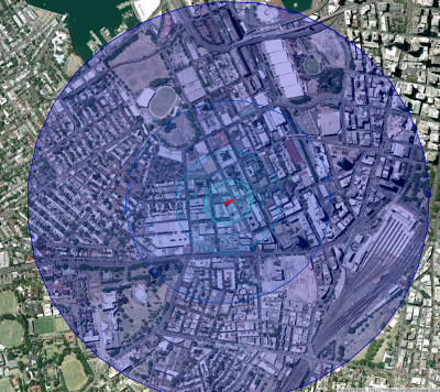
OpenEarth can "add space" to your existing alphanumeric solutions or "add openness" to your existing spatial solutions. We can provide Open Source functions to access your existing local or remote data, improve its usefullness by adding location information and spatial context such as addressing and administrative area (suburbs, postcodes) and present the enhanced information in many ways including the results of spatial analysis (How close...?, how many...?, where...?) interactive 2D and 3D maps, business graphics or high resolution spatial images suitable for printing. We can also take data from your existing GIS and present it cheaply and efficiently to a wide audience of users without the need for user and licensing management.
Evaluating Existing Spatial Systems

OpenEarth can review your existing spatial systems without a vendor's bias. While we obviously charge for our time, the products we propose are free and ubiquitous with excellent, world-wide support through an active user and development base.
Everything we develop for you is yours so you can continue to modify and improve it yourself or hand it on to others with the same skills. Open Source means you're not tied to specific, vendor-approved help.
Some of the skills OpenEarth can offer in evaluating your current spatial systems include:
- Inventoring existing systems - products, versions, compatibilities, licensing, training and support costs etc.
- Understanding how the various components are being used. Are they being utilised to their maximum capabilities?
- Identifying gaps and duplications in systems
- Proposing, if appropriate, alternative or supplementary tools and approaches
- Designing and documenting the elements necessary to make the improvements
- Writing and implementing the proposed changes
- Hosting development and test sites and, if required, hosting the final solutions or add-ons
While Open Source spatial tools are some of the most powerful and flexible available and are constantly improving, there are cases where an existing proprietary system "just works" and is the best solution for a specific task. OpenEarth can determine how well your current solution meets the requirements of staff, customers and other users. We can suggest specific areas where an alternative technology could improve things in terms of performance, flexibility, scaleability, usability etc.
Design of New Systems

OpenEarth have many years experience in designing and implementing spatial solutions in a wide range of markets, especially for Telecoms.
We can consult, design, build and host a solution to meet your exact requirements using an agreed set of components.
We can also integrate new functionality into or beside existing systems and replace old functions with faster, more efficient and open alternatives.
OpenEarth have produced complete start-to-finish spatial systems for telecoms, software companies and transport fleet management, amongst other commissions.
Spatial Sourcing
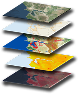
The volume, quality and availability of Spatial Data is growing by the day. Every satellite, every geographically-distributed network, creates large volumes of valuable and interesting data. OpenEarth can help search, discover, evaluate and utilise the right datasets to suit your specific needs.
We can determine the best options for data access based on issues such as currency, accuracy and precision, volatility and likely network impact and then implement the best local or remote, static or dynamic, file, database or API-based methods of data storage and access.
Dynamic Design
Dynamic Design is an international company, with headquarters in Switzerland, providing a range of solutions for managing networks, especially in the telecoms market.
Their products are based totally on proprietary tools; database, middleware, spatial tools (GIS) and user interface. While these tools were appropriate in 1993 when the company was founded, and have supported development through the years, the ever-growing issues of licensing costs and management requirements; version managment of multiple products; a lack of control over changes or improvements to these essential components and a growing international customer base meant that easier, simpler alternatives were being actively canvassed.
OpenEarth provided consultancy into Dynamic Design in its Melbourne offices to establish just what could be accomplished with Open Source alternatives to their existing proprietary tools. After some initial familiarisation, OpenEarth was able to show how the Spatial Database, Spatial Server, User Interface and Data Import and Export tools could all be replaced or supplemented with Open Sources equivalents. OpenEarth was also able to provide browser-based proof-of-concept vector graphics using Open Source graphics libraries essentially equivalent to, and as functional as, those of the existing Dynamic Design desktop solution.
The consultancy proved conclusively, that Open Source Spatial solutions could replace most if not all their existing proprietary tools and remove entirely, issues of licensing on customer systems. Customer Support would also benefit as full control was available over all components of their solution, along with the active, vibrant world-wide support community that characterises the best Open Source solutions.
It showed that by adopting Open Source alternatives for some or all of its external tools, Dynamic Design would be able to provide its solutions without external and third-party licensing requirements, making the setting up of new clients considerably easier and cheaper. In addition, by changing to a browser-based User Interface using Open Source graphics libraries, it became realistic to consider providing it products as Services delivered over the web. Because Open Source Spatial solutions provided Dynamic Design developers full access to source, they could also optimise the tools themselves, enabling better control and so a better experience for their users.
Virgin Mobile Location Services
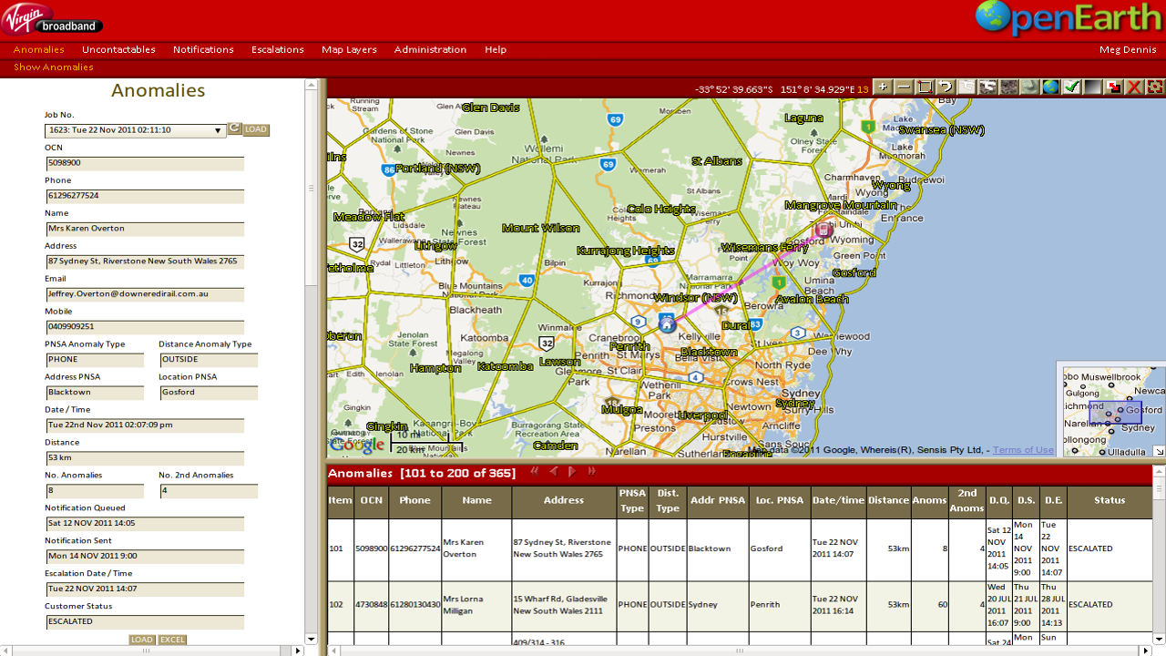
OpenEarth was approached by an Australian Mobile Telecoms company, Virgin Mobile, with a spatial problem. Virgin wished to sell a home broadband solution Virgin Broadband At Home which utilised their existing 4G network and included a home phone with an allocated land-line number.
Australia's Emergency Services conventions required that every Land-Line number (+61 x xxx xxxx) be spatially located and provided to a centralised database, the Integrated Public Number Database (IPND) from which emergency operators throughout the country could automatically identify a location simply from the telephone number from which a call was being made. This meant that the At Home devices needed to remain at the location provided when the devices were purchased and that any subsequent changes of address were noted and the new address provided to the IPND. The problem was that the At Home devices were small and portable and would work anywhere. The challenge was to identify when devices moved outside their approved location and communicate, as automatically as possible, with the device owners.
OpenEarth designed, built, tested and hosted a system which provided the exact service required to fulfil IPND requirements. The system
- Accessed Virgin Customer Management systems to extract a list of new, changed and dropped At Home devices.
- Use the provided address to geo-locate the device's authorised location for subsequent comparisons
- Updated its own Open Source Spatial database, PostGIS/PostgreSQL so that customer details properly reflected Virgin's Customer Database.
- Nightly use Virgin's GSM Location Services API to interrogate the location of each At Home device.
- Determine, using a flexible set of algorithms, whether the device location was within a designated area. This was based on distance of the device from cell towers, location accuracy, the device's history of previous movements, whether the device location crossed various administration boundaries and a number of other contributing factors.
- If the device was out-of-place, to issue SMS and/or Email messages requesting the device to be returned to its authorised location - a sequence of different messages were sent depending on whether the device was still out of place.
- Finally escalate issues, if necessary, to Virgin Customer Service from where staff then contacted the device owners
- Provide a Map-based tool for Virgin staff to monitor all devices
- Provide various reports in Excel, CSV and PDF formats for input into other Virgin Services
The system was successfully implemented and hosted by OpenEarth. It ran for approximately five years until the At Home product was replaced with new technologies that allowed handsets to become WiFi Points of Presence and use of landline numbers was no longer required.
Optus Location Services
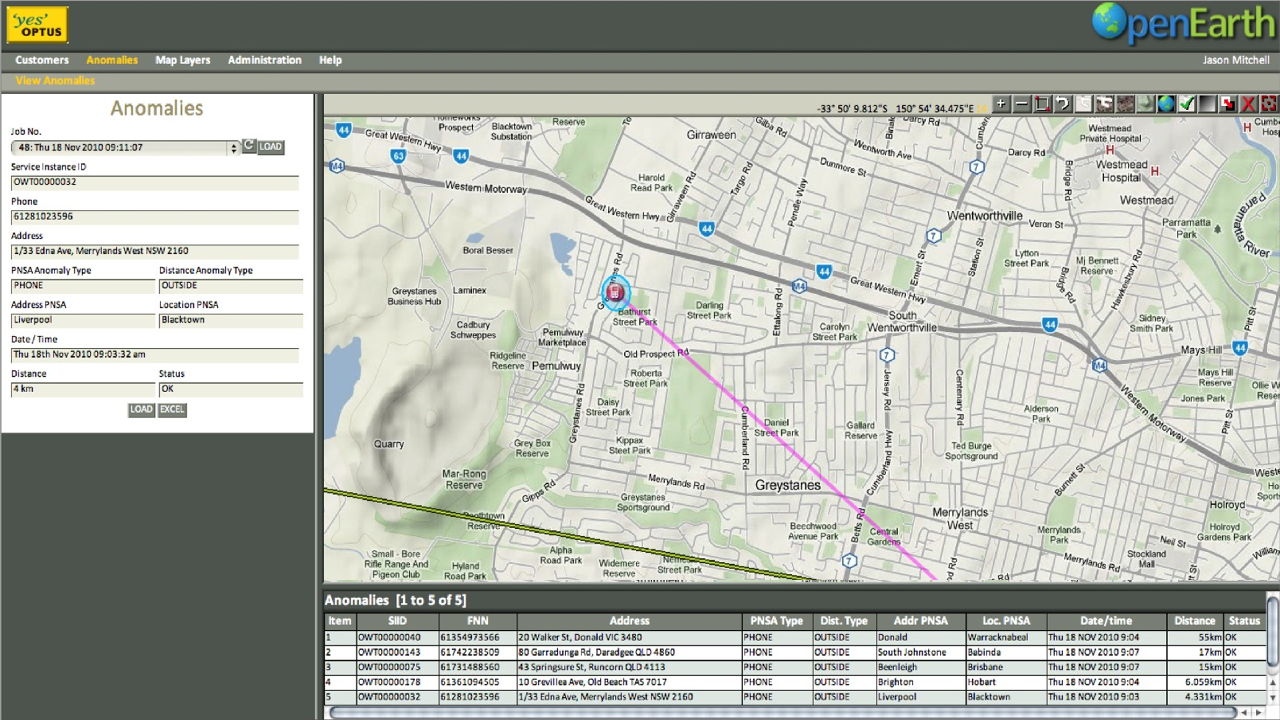
Based on previous, successful services provided to Virgin Mobile, OpenEarth developed a similar device location and reporting service for Optus Networks. The system provided comprehensive monitoring and reporting facilities customised to the Optus Customer model.
The Optus system performed a function similar to that developed for Virgin which was monitor, control and report on devices that were contractually required to remain in designated "Home Areas".
Optus Reseller Location Services
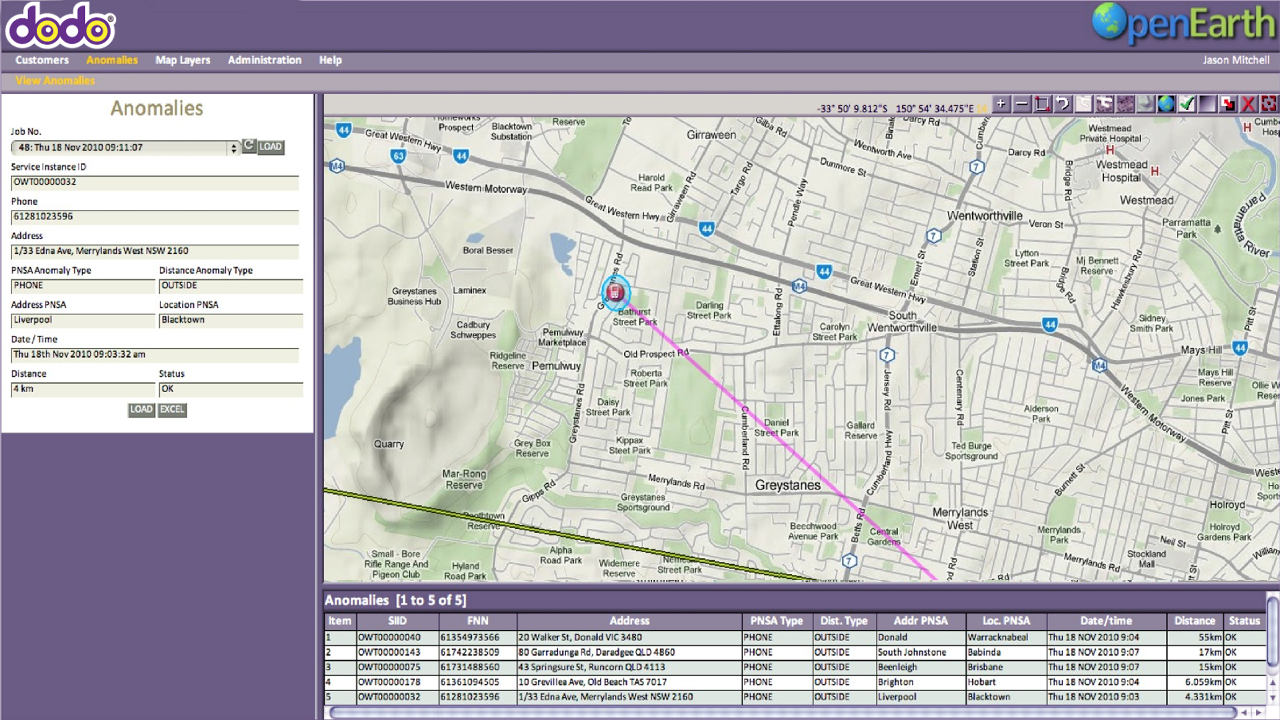
Based on previous, successful services provided to Virgin Mobile, and Optus, OpenEarth was further asked to develop and host a customisable device location and reporting service for Optus Networks Resellers. This allowed the service to be customised to meet the various needs of each of the Optus Resellers.
The system provided comprehensive monitoring and reporting facilities customised to each Optus Reseller's model. The system performed a function similar to that developed for other products which was to monitor and control devices that were contractually required to remain in designated "Home Areas".
Nangi Health Database
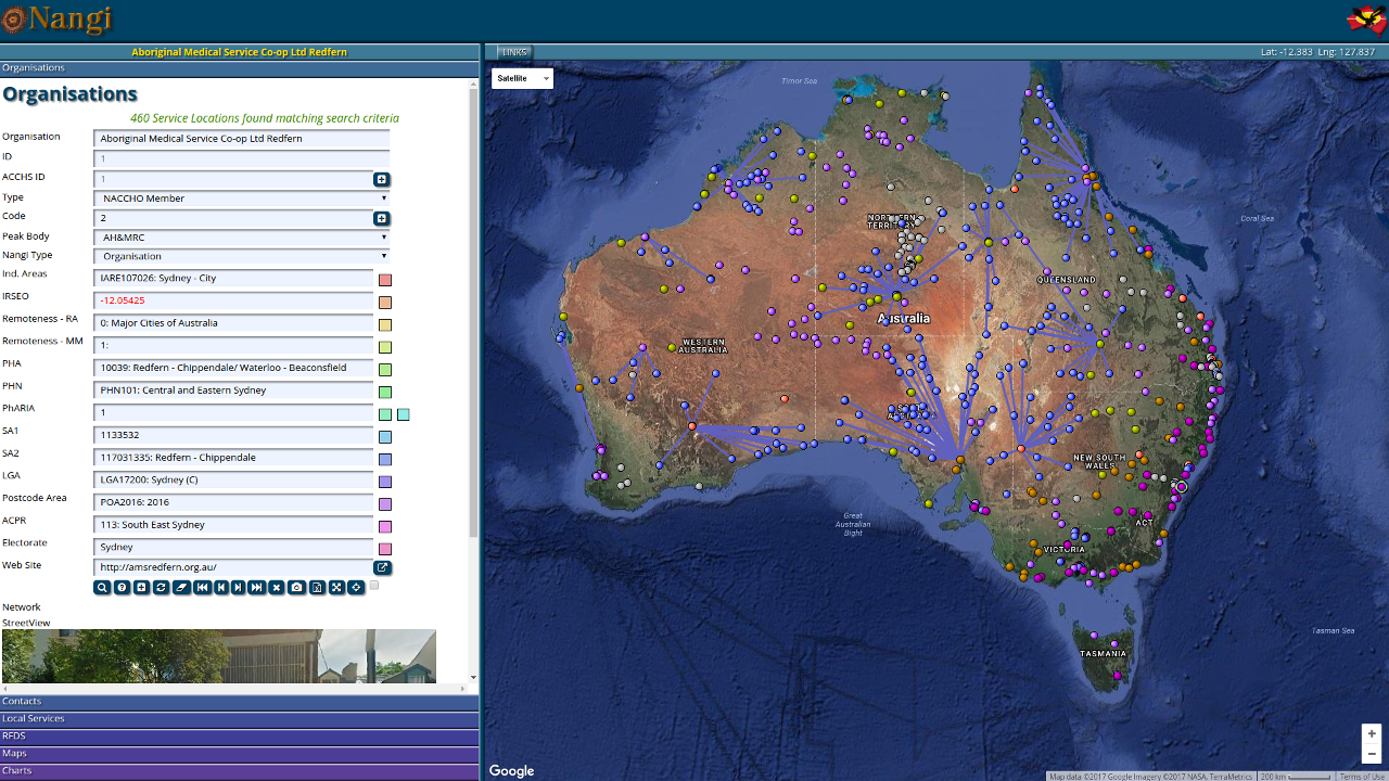
Nangi ("to see" or "to look" in the language of the Ngunnawal people of Canberrra) was developed for the peak Aboriginal Health body, NACCHO to bring together a wide range of information on the Aboriginal peoples of Australia; to understand where they were physically placed and to identify the Health resources available to them.
OpenEarth consulted, designed, developed and hosted the Nangi Site allowing NACCHO member organisations an integrated, map-centric view of the state of the State of Australian Aboriginal Health.
Quality Use Of Medicines
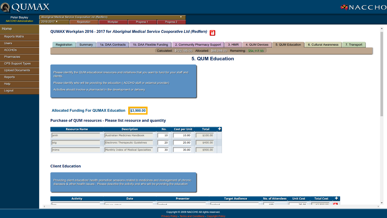
QMAX represents a key factor in ensuring good health outcomes - ensuring a regime of proper and timely medication. QUMAX helps patients with complex medications using a number of simple measures along with careful monitoring and measurement.
A significant upgrade to the QUMAX system was designed and implemented by OpenEarth for NACCHO, the National body responsible for QUMAX Administration. It supports the development of Workplans covering the seven key QUMAX areas along with two Progress Reports each year which ensure the workpans are being effected.
Cadastral Management
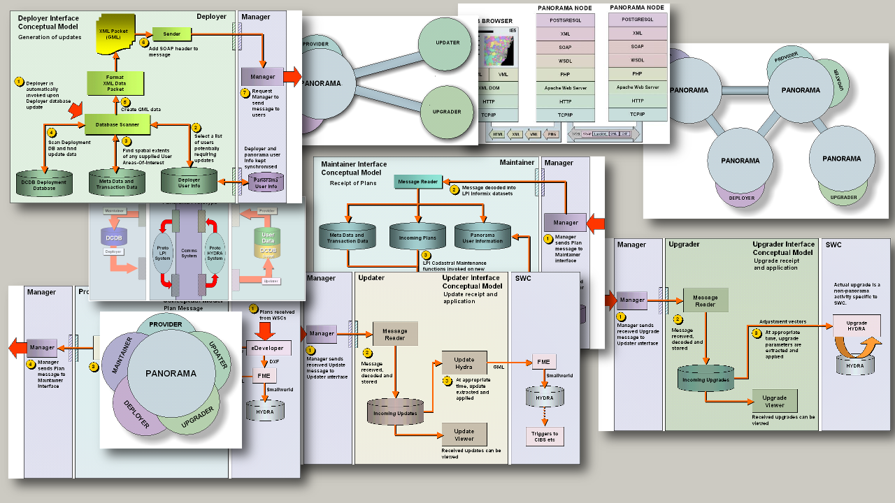
OpenEarth consulted with the New South Wales Land Information Centre (LIC) to design a service that allowed surveyers and developers to submit plans and surveys online with automatic detection of CAD features and reading of the drawings into a spatial database.
Part of the work was an evaluation of two Cadastral (Property Title) databases one at LIS and the other at Sydney Water. The analysis highlighted differences and errors between the two cadastres such that a successful merge of the two cadastres could be implemented.The Panorama system demonstrated a full workflow of new property development from acceptance of CAD drawings through incorporation into provisional spatial database layers and publishing of the new data versions in formas that could be used to update assets tied to the cadastre (cadastral shift).
National Address Management Framework
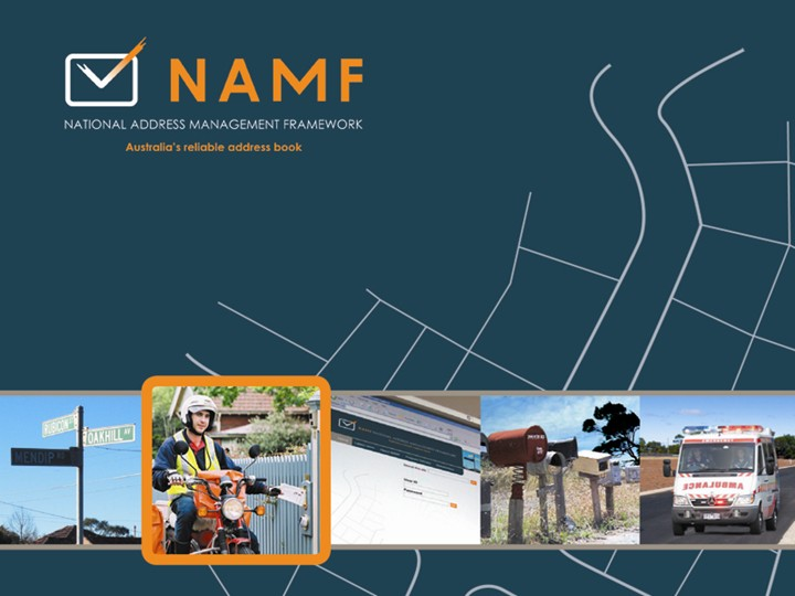
OpenEarth provided consultancy to the Australia New Zealand Land Information Council (ANZLIC) to review all aspects of addressing in Australia, interview key participants and provide three deliverables:
A Standard Address Data Model.
A Standard Address Transfer Format.
A Standard Address Web Services Interface.
OpenEarth researched and conducted interviews for all three deliverables but was most involved in designing, implementing and documenting the Web Services Interface which provided API access to NAMF-compliant Address Services.
Aboriginal Community Controlled Health Services
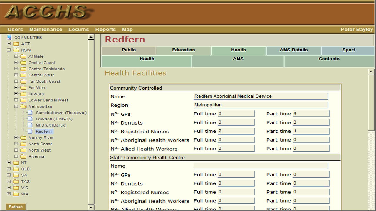
There are approximately 150 ACCHS across Australia providing Primary Healthcare to Indigenous Australians. OpenEarth developed a custom tool to allow the gathering, analysis and reporting of information on these organisations and on the communities within which their services were offered. The ACCHS site locations themselves as well as the locations of outstations and clinics were mapped so that their potential population catchments could be estimated and reported on as an aid in planning future requirements.
The ACCHS Tool collated a large amount of previously-scattered data and so helped the organisations better understand their areas of responsibility (local, regional, state and national) and so imporove the coordination of their efforts, resulting in significant savings in both time and resources.
MapChat
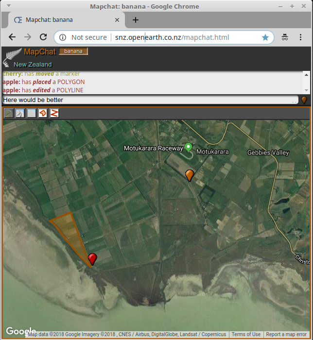
MapChat is a simple service that allows multiple map viewers to be coordinated across the web so that a map-enhanced and informed conversation can be held about particular locations. As MapChat is still in development, the best way to show its early capabilities is with the short (6min) video below. The communication mechanism between Map Clients is very quick with minimal overhead. In the video, the messages between the various browser pages (in Christchurch NZ) are being transmitted through a server in Melbourne, Australia.
View the MapChat Demonstration Video
There are many possible use cases for a map collaboration facility such as MapChat. OpenEarth are always keen to hear how the underlying technologies can be used to solve other user issues.
If you'd like to try the actual MapChat tool, assuming the Server is running, you can access the client here. You are best off using the Google Maps client at the moment as the other clients have varying amounts of functionality. The Cesium 3D client allows three dimensional navigation but does not yet have the drawing functions enabled.
Spatial Publishing
While the creation and analysis of spatial data is usually a specialist task, the results of those activities need to be easily available to a wide range of users with the ability for them to further use the results in their own ways. Typically a small number of analytical processes generate data that many more users want access to.
OpenEarth can provide customised services that "publish" the results using Open Source tools that require no licensing and can be freely scaled to meet user demands.
Smart Images
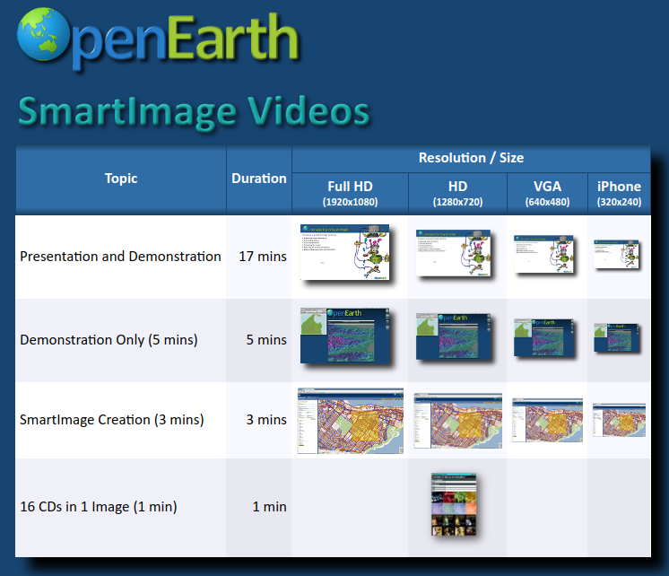
Images are a great way to convey information and are in use throughout the web. But they are just pictures - arrays of coloured dots. So providing further information about what the image represents requires considerable extra work.
But what if the image itself could supply that other information? This is the problem Smart Images solves. Smart Images are ordinary images in every way but have extra content that can be used to make the image interactive and Smart
To better understand how Smart Images can be used, please select from these short video presentations that illustrate some uses of SmartImages.
Spatial New Zealand

Imagine a simple tool that lets people throughout New Zealand cooperate in space. By that, we mean a set of spatial functions that can be connected together in various ways so that each participant can see and interact with what others are doing. Spatial systems that cooperate with each other and with multiple data sources to form a single, virtual system that everyone can use. The idea is similar to MMORPG - an acronym from the Video Games world meaning "Massively Multiplayer Online Role-Playing Game"
Spatial New Zealand is the idea of building an integrated, customised suite of spatial tools using the very best open source products and then integrating them with a layer of connectivity so that they form a single, cohesive model of the entire country, a model which can be viewed initially as the familiar interactive map that everyone knows, but eventually can become an continuous immersive Virtual Reality and/or Augmented Reality experience.
The idea of connecting people is not new. In fact it's the very basis of Social Media. But few connecting technologies connect people Spatially - so that each can see what others are doing and interact by drawing things, pointing at things, adding in things. The closest technology existing technology along these lines is MMORPG or Massively Multiplayer Online Role-playing Games Spatial New Zealand would be just such a service. Some of its features would include:
-
Use ONLY Best of Breed Open Source software so that anyone can take and extend the concept - no proprietary content Some examples:
- PostGIS / PostgreSQL Spatial Database
- The OSGEO Suite of Open Source Spatial Projects including
- GeoServer middleware
- Open Layers Web Mapping Libraries
- Open Source Data - so that anyone can access the data needed to render useful maps. This doesn't preclude other, private datasets being added in for a restricted set of participants. Open Street Map is a good example of Open Source Data. New Zealand datasets could be used to enrich OSM Data so that everyone could enjoy a comprehensive experience of New Zealand
- Why Spatial?. Because maps are a natural way of bringing information together and creating new contexts. People can quickly see coincidence between datasets that are otherwise completely separate.
- Map Collaboration. The MapChat tool, currently in development is an early example of using maps for cooperation, coordination and collaboration.